


SARATOGA TWP Voting District, Howard County, Iowa
About
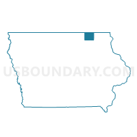
Outline

Summary
| Unique Area Identifier | 582330 |
| Name | SARATOGA TWP Voting District |
| County | Howard County |
| State | Iowa |
| Area (square miles) | 38.84 |
| Land Area (square miles) | 38.83 |
| Water Area (square miles) | 0.01 |
| % of Land Area | 99.98 |
| % of Water Area | 0.02 |
| Latitude of the Internal Point | 43.38286650 |
| Longtitude of the Internal Point | -92.37310290 |
Maps


Graphs
Select a template below for downloading or customizing gragh for SARATOGA TWP Voting District, Howard County, Iowa


Neighbors
Neighoring Voting District (by Name) Neighboring Voting District on the Map
- AFTON TWP W/O ELMA Voting District, Howard County, IA
- CHESTER TWP Voting District, Howard County, IA
- FOREST CITY TWP Voting District, Howard County, IA
- HOWARD CENTER TWP Voting District, Howard County, IA
- HOWARD TWP W/O ELMA Voting District, Howard County, IA
- JAMESTOWN TWP W/O RICEVILLE Voting District, Howard County, IA
- OAK DALE TWP Voting District, Howard County, IA
- PARIS TWP Voting District, Howard County, IA
Top 10 Neighboring County Subdivision (by Population) Neighboring County Subdivision on the Map
- Afton township, Howard County, IA (813)
- Forest City township, Howard County, IA (768)
- Jamestown township, Howard County, IA (595)
- Howard township, Howard County, IA (508)
- Paris township, Howard County, IA (307)
- Chester township, Howard County, IA (277)
- Saratoga township, Howard County, IA (262)
- Howard Center township, Howard County, IA (232)
- Oak Dale township, Howard County, IA (190)
Top 10 Neighboring Unified School District (by Population) Neighboring Unified School District on the Map
- Howard-Winneshiek Community School District, IA (9,186)
- Riceville Community School District, IA (2,667)